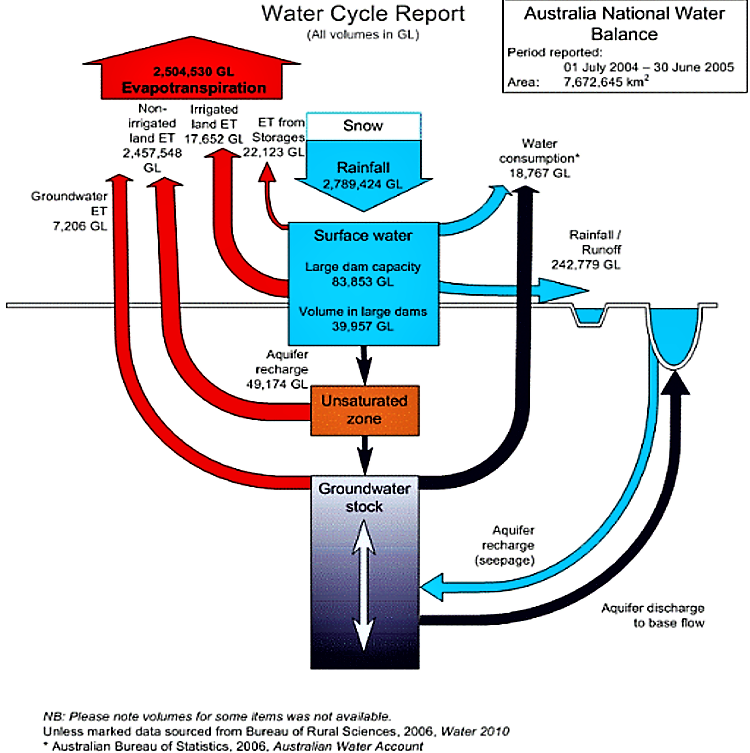
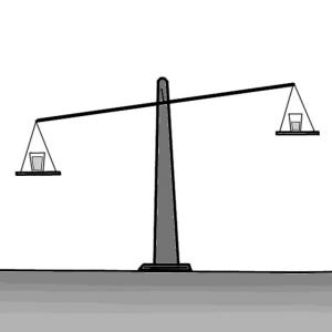
Water balance estimation is an important tool to assess the current status and trends in water resource availability in an area over a specific period of time. Furthermore, water balance estimates strengthen water management decision-making, by assessing and improving the validity of visions, scenarios and strategies.
In the natural environment, water is almost constantly in motion and is able to change state from liquid to a solid or a vapour under appropriate conditions. Conservation of mass requires that, within a specific area over a specific period of time, water inflows are equal to water outflows, plus or minus any change of storage within the area of interest. Put more simply, the water entering an area has to leave the area or be stored within the area. The simplest form of water balance equation is as follows:
P = Q + E ± ∆S
Where, P is precipitation, Q is runoff, E is evaporation and ∆S is the storage in the soil, aquifers or reservoirs.
In water balance analysis, it is often useful to divide water flows into ‘green’ and ‘blue’ water. ‘Blue’ water is the surface and groundwater that is available for irrigation urban and industrial use and environmental flows. ‘Green’ water is water that has been stored in the soil and that evaporates into the atmosphere. The source of ‘green’ water is rainfall or ‘blue’ water has been used for irrigation.
A Water Balance Analysis Can Be Used to:
- Assess the current status and trends in water resource availability in an area over a specific period of time.
- Strengthen water management decision-making, by assessing and improving the validity of visions, scenarios and strategies.
Water balance estimates are often presented as being precise. In fact, there is always uncertainly, arising from inadequate data capture networks, measurement errors and the complex spatial and temporal heterogeneity that characterises hydrological processes. Consequently, uncertainty analysis is an important part of water balance estimation as is quality control of information before used.
When the data sources are imprecise, it is often possible to omit components that do not affect changes. For example, it is possible to omit storage from an annual water balance if year-on-year storage changes (such as reservoirs) are negligible.
Some common problems that occur when water balance estimations are made include:
- Temporal and spatial boundaries are not defined.
- The quality of input data is poor.
- Double counting of water flows when water flows within an area added to water flow exiting area.
- Inappropriate extrapolation of field level information to a larger scale. Many hydrological relationships are scale dependent (e.g. runoff as a proportion of rainfall is almost always higher at smaller spatial and temporal scales).
- Intuition (often based on popular myths) is used rather than good quality information.
- The storage term(s) of the water balance is omitted.
- Political or other pressures result in unreliable estimates that have been manipulated.
Almost everyone is influenced by the water balance estimates because they are often central elements of awareness raising campaigns. Stakeholders directly involved in decision making may require more detailed information about the water available. Given that water balance analysis should be based on a needs assessment, everyone is involved in determining the outputs that are needed. The process of producing water estimates is best undertaken by experienced specialists or by staff who have undergone training and have access to specialist support.
Techniques for carrying out water balance estimation range from very simple ‘back of the envelope’ estimates to highly complex computer-based models. A sound knowledge of hydrological processes of a prerequisite of water balance estimation. It is often advisable for a project or programme to employ the services of a specialist to produce water balance estimates or, at the very last, to provide specialist advice as and when it is needed. Access to a quality-controlled information base is a good starting point for water balance estimation.

Subscribe here to the new Sanitation and Water Entrepreneurship Pact (SWEP) newsletter. SWEP is a network of organizations joining hands to help entrepreneurs design and develop lasting water and sanitation businesses.
Step 1
Define boundaries of the area of interest and period over which water balance is to be made.
Step 2
Undertake a needs assessment of the water balance information that is required among stakeholders. This should be used as a starting point for listing and defining the water balance components that are of particular interest.
Step 3
Produce a simply schematic diagram that shows storage, inflows and outflows from the area of interests. Use the diagram as a basis for drafting a water balance equation. Check that no components are missing and that is no double counting of flows or storage.
Step 4
Identify a source(s) of quality-controlled information. Ensure that the information is relevant to the area and time period you are interested in.
Step 5
Carry out uncertainty and sensitivity analysis on this information. If there are inadequacies in the information (almost always the case), redefine the boundaries of the water balance and/or modify the water balance equation.
Step 6
Produce water balance estimates in a format that is useful for visioning, scenario building and planning with the community.
Step 7
Control these estimates regarding their quality before they are disseminated, using quality control methods described in this chapter.
Step 8
Disseminate findings to stakeholders in a form that they can understand (see also creating information material).
One tool with which you can carry out a professional water balance analysis is the WEAP (Water Evaluation And Planning) Tool – you find it here.
Water balance techniques, one of the main subjects in hydrology, are a means of solution of important theoretical and practical hydrological problems. On the basis of the water balance approach, it is possible to make a quantitative evaluation of water resources and their change under the influence of people's activities. The study of the water balance structure of lakes, river basins, and ground-water basins forms a basis for the hydrological substantiation of projects for the rational use, control and redistribution of water resources in time and space (SOKOLOV & CHAPMAN 1974).
The EMPOWERS Approach to Water Governance: Guidelines, Methods and Tools
The guideline provides information necessary to understand the EMPOWERS approach of water governance and explains in details how to use the approach for planning and implementation of water management and related issues.
MORIARTY, P. BATCHELOR, C. ABD-ALHADI, F. LABAN, P. FAHMY, H. (2007a): INWRDAM The EMPOWERS Approach to Water Governance: Guidelines, Methods and Tools. pdf presentation. Amman, Jordan: Inter-Islamic Network on Water Resources Development and Management (INWRDAM) URL [Visita: 18.03.2010]Australian Water Resources 2005 - Water Balance Assessment
Methods for water balanced computations
Water Evaluation And Planning (WEAP)
The EMPOWERS Approach to Water Governance: Guidelines, Methods and Tools
The guideline provides information necessary to understand the EMPOWERS approach of water governance and explains in details how to use the approach for planning and implementation of water management and related issues.
MORIARTY, P. BATCHELOR, C. ABD-ALHADI, F. LABAN, P. FAHMY, H. (2007a): INWRDAM The EMPOWERS Approach to Water Governance: Guidelines, Methods and Tools. pdf presentation. Amman, Jordan: Inter-Islamic Network on Water Resources Development and Management (INWRDAM) URL [Visita: 18.03.2010]Estimation of Groundwater Recharge Using Water Balance Model
The main purpose of this paper is to apply a water balance concept with two models in the Ching–Shui watershed to describe the groundwater recharge.
HSIN-FU YEH, H. LEE, C. CHEN, J. CHEN, W. (2007): Estimation of Groundwater Recharge Using Water Balance Model. Tainan: National Cheng Kung University. Kaohsiung Kao Yuan Institute of Technology URL [Visita: 10.04.2019]Asian Water Development Outlook 2013. Measuring Water Security in Asia and the Pacific
This second edition of the Asian Water Development Outlook (AWDO) provides a quantitative and comprehensive view of water security in the countries of Asia and the Pacific. By focusing on critical water issues, AWDO 2013 provides finance and planning leaders with recommendations on policy actions to improve water governance and guidance on investments to increase their country's water security
ADB (2013): Asian Water Development Outlook 2013. Measuring Water Security in Asia and the Pacific. Manila: Asian Development Bank (ADB) URL [Visita: 28.03.2013]Management of aquifer recharge and discharge processes and aquifer storage equilibrium
This paper draws attention to case studies from a range of hydro-geological, climatic and societal settings where innovative management has been successful in reversing groundwater storage declines (or increases). Informing and engaging stakeholders in governance has resulted in more resilient outcomes that take better account of local needs. Importantly, in many settings local action by motivated communities has run ahead of state and national policies and been highly effective in managing groundwater storage, increasing farm incomes and protecting the environment.
FAO GEF IAH IHP World Bank (2012): Management of aquifer recharge and discharge processes and aquifer storage equilibrium. Food and Agriculture Organization (FAO) URL [Visita: 08.04.2013]Water balance estimation in Anthemountas river basin and correlation with underground water level
This is a short paper about the estimation of annual water balance in the Anthemountas river basin.
FIKOS, I. ZIANKAS, G. RIZOPOULOU, A. FAMELLOS, S. (2005): Water balance estimation in Anthemountas river basin and correlation with underground water level. Thessaloniki: Development Agency of Eastern Thessaloniki URL [Visita: 10.04.2019]Estimating direct groundwater recharge using a simple water balance model – sensitivity to land surface parameters
This paper describes a sensitivity analysis of a simple water balance model to determine the parameters having the greatest influence on estimates of recharge.
FINCH, J.W. (1998): Estimating direct groundwater recharge using a simple water balance model – sensitivity to land surface parameters. Wallingford: Institute of Hydrology URL [Visita: 10.04.2019]Hydrologic balance estimation using GIS in Korinthia prefecture, Greece
The main objective of this piece of work is to determine the hydrological balance for several basins in the prefecture of Korinthia (SE Greece), using hydrometeorological data and geographic information systems (GIS) technology.
VOUDOURIS, K. MAVROMMATIS, TH. ANTONAKOS, A. (2007): Hydrologic balance estimation using GIS in Korinthia prefecture, Greece. Thessaloniki, Patras: Aristotle University, University of Patras URL [Visita: 17.11.2010]Water Scarcity Factsheet
Thematic Factsheet on Water Scarcity. The world contains an estimated 1 400 million cubic km of water. Only 0.003% of this vast amount, about 45 000 cubic km, are what is called "fresh water resources", i.e. water that can be used for drinking, hygiene, agriculture and industry.
UN Water (2013): Water Scarcity Factsheet. United Nations Water URL [Visita: 09.04.2019]WEAP "Water Evaluation And Planning" system
This tool is a user-friendly software tool that takes an integrated approach to water resources planning. The tool is not free of cost, but helps you to carry out a professional water balance analysis of your area.
Estimation of Water Balance Components in the Hasa Basin with GIS based WetSpass Model
On this website you can find a research article about an estimation of water balance components in the Hasa basin (Jordan) with GIS based WetSpass model.


